Geolocate

Ramsey topographic map

Click on the map to display elevation.

About this map
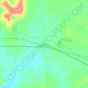
Name: Ramsey topographic map, elevation, terrain.

Location: Ramsey, Harrison County, Indiana, 47166, United States (38.30368 -86.17470 38.34368 -86.13470)

Average elevation: 725 ft

Minimum elevation: 643 ft

Maximum elevation: 912 ft

Harrison County trails, hiking, mountain biking, running and outdoor activities

Other topographic maps

Click on a map to view its topography, its elevation and its terrain.
New Amsterdam

United States > Indiana > Harrison County

Average elevation: 495 ft

New Middletown

United States > Indiana > Harrison County

Average elevation: 705 ft

Crandall

United States > Indiana > Harrison County

Average elevation: 712 ft

Laconia

United States > Indiana > Harrison County

Average elevation: 659 ft

Gear up for your next adventure:

🖼️Topo Map Wall Art - Decorative topographic prints of famous peaks and regions
🌲Outdoor Survival Books - Best books on survival skills
🎒Gear Packing Cubes - Organize your backpack efficiently
☕Camping Coffee Makers - Enjoy premium coffee at the summit or campsite
☀️Outdoor Sunscreen - High protection sunscreen for outdoor activities

As an Amazon Associate, this site earns from qualifying purchases at no extra cost to you.