Geolocate

Porter topographic map

Click on the map to display elevation.

About this map
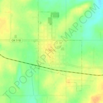
Name: Porter topographic map, elevation, terrain.

Location: Porter, Wagoner County, Oklahoma, 74454, United States (35.85765 -95.52828 35.87844 -95.51274)

Average elevation: 623 ft

Minimum elevation: 564 ft

Maximum elevation: 673 ft

Wagoner County trails, hiking, mountain biking, running and outdoor activities

Other topographic maps

Click on a map to view its topography, its elevation and its terrain.
New Tulsa

United States > Oklahoma > Wagoner County

Average elevation: 666 ft

Taylor Ferry

United States > Oklahoma > Wagoner County

Average elevation: 607 ft

Gear up for your next adventure:

🛰️Handheld GPS Units - Professional satellite navigators for precise backcountry mapping
🌄Hiking Binoculars - Compact binoculars for scenic views and trail spotting
🪑Ultralight Camp Chairs - Portable seating for resting after a long day of mapping
🗃️Trail First Aid Kit - Essential kit for outdoor injuries and emergencies
🔪Outdoor Multitools - Essential survival tools for gear repair and field use

As an Amazon Associate, this site earns from qualifying purchases at no extra cost to you.