Geolocate

Pokaran topographic map

Click on the map to display elevation.

👉 Easily get elevation data in JSON, GeoTIFF and KML formats using Elevation API
Thank you for supporting this site ❤️
Make a donation

Pokaran

Pokhran is located 112 km east of Jaisalmer city, 172 km northwest of Jodhpur and 225 km south of Bikaner by road. It lies on Jaisalmer to Jodhpur railway line. It is situated at 27°05′42″N 71°45′11″E / 27.095°N 71.753°E / 27.095; 71.753 and has an average elevation of 233 metres (764 feet).

Wikipedia (CC-BY-SA 3.0)

About this map

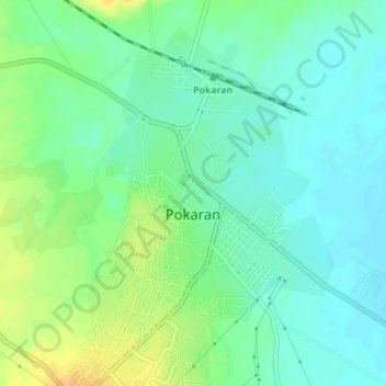
Name: Pokaran topographic map, elevation, terrain.

Location: Pokaran, Pokaran Tehsil, Jaisalmer District, Rajasthan, India (26.90607 71.90272 26.93711 71.92982)

Average elevation: 751 ft

Minimum elevation: 712 ft

Maximum elevation: 817 ft

Gear up for your next adventure:

🧺Microfiber Travel Towels - Compact and fast-drying towels for trail use
🧭Map Reading Tools - Tools and kits for map navigation
🌄Hiking Binoculars - Compact binoculars for scenic views and trail spotting
🔥Camping Stove - Portable stove for camping and backcountry cooking
🌲Outdoor Survival Books - Best books on survival skills

As an Amazon Associate, this site earns from qualifying purchases at no extra cost to you.