Geolocate

Morbi topographic map

Click on the map to display elevation.

About this map

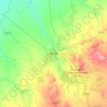
Name: Morbi topographic map, elevation, terrain.

Location: Morbi, Morbi Taluka, Morbi District, Gujarat, 363600, India (22.65767 70.67459 22.97767 70.99459)

Average elevation: 174 ft

Minimum elevation: 39 ft

Maximum elevation: 390 ft

Other topographic maps

Click on a map to view its topography, its elevation and its terrain.

Rajpur

India > Gujarat > Morbi Taluka

Average elevation: 187 ft

Gear up for your next adventure:

🛡️Bear Spray Outdoor - Protection in bear country hikes
🛏️Cold Weather Sleeping Bag - Warm sleeping bag for cold conditions
🔪Outdoor Multitools - Essential survival tools for gear repair and field use
🔊Portable Camp Speaker - Music and alerts at camp
🧯Portable Fire Pit - Compact fire pit for camping spots

As an Amazon Associate, this site earns from qualifying purchases at no extra cost to you.