
Thank you for supporting this site ❤️
Make a donation
Make a donation
Gear up for your next adventure:
As an Amazon Associate, this site earns from qualifying purchases at no extra cost to you.
Otieri/Ozieri topographic map
Click on the map to display elevation.
Thank you for supporting this site ❤️
Make a donation
Make a donation
Gear up for your next adventure:
As an Amazon Associate, this site earns from qualifying purchases at no extra cost to you.
About this map
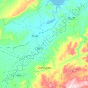
Name: Otieri/Ozieri topographic map, elevation, terrain.
Location: Otieri/Ozieri, Sassari, Sardinia, 07014, Italy (40.53515 8.83760 40.75427 9.05764)
Average elevation: 1,135 ft
Minimum elevation: 499 ft
Maximum elevation: 3,212 ft
Thank you for supporting this site ❤️
Make a donation
Make a donation
Gear up for your next adventure:
As an Amazon Associate, this site earns from qualifying purchases at no extra cost to you.
Other topographic maps
Click on a map to view its topography, its elevation and its terrain.