Geolocate

Mosgiel topographic map

Click on the map to display elevation.

About this map

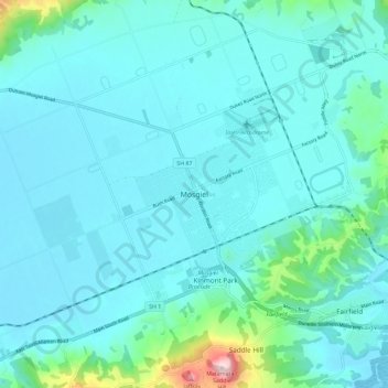
Name: Mosgiel topographic map, elevation, terrain.

Location: Mosgiel, Dunedin City, Otago, 9024, New Zealand (-45.91498 170.30735 -45.83498 170.38735)

Average elevation: 180 ft

Minimum elevation: -3 ft

Maximum elevation: 1,522 ft

Gear up for your next adventure:

📖Nature Tracking Books - Learn to track wildlife and terrain
🗻Climbing Gear Basics - Essential gear for beginner climbers
🏕️Tent Footprint - Protect your tent base from wear
🌧️Backpack Rain Cover - Keep gear dry in wet weather
📚Navigation Handbooks - Master the art of reading topographic maps and using a compass

As an Amazon Associate, this site earns from qualifying purchases at no extra cost to you.