Geolocate

Mona topographic map

Click on the map to display elevation.

About this map

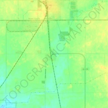
Name: Mona topographic map, elevation, terrain.

Location: Mona, Mitchell County, Iowa, 55953, United States (43.46719 -92.96130 43.50719 -92.92130)

Average elevation: 1,181 ft

Minimum elevation: 1,135 ft

Maximum elevation: 1,217 ft

Mitchell County trails, hiking, mountain biking, running and outdoor activities

Other topographic maps

Click on a map to view its topography, its elevation and its terrain.

Orchard

United States > Iowa > Mitchell County

Average elevation: 1,089 ft

Carpenter

United States > Iowa > Mitchell County

Average elevation: 1,191 ft

McIntire

United States > Iowa > Mitchell County

Average elevation: 1,276 ft

Saint Ansgar

United States > Iowa > Mitchell County

Average elevation: 1,161 ft

Mitchell

United States > Iowa > Mitchell County

Average elevation: 1,171 ft

Gear up for your next adventure:

🚁Photography Drones - Capture stunning aerial views of landforms and topography
📦Dry Bags Set - Waterproof storage for electronics and clothes
🥘Titanium Cookware - Durable, featherlight pots and pans for backpacking
🪶Wildlife Field Guides - Learn animal tracking and species ID
👓Polarized Sunglasses - Outdoor sunglasses for glare reduction

As an Amazon Associate, this site earns from qualifying purchases at no extra cost to you.