Geolocate

Chuping topographic map

Click on the map to display elevation.

About this map

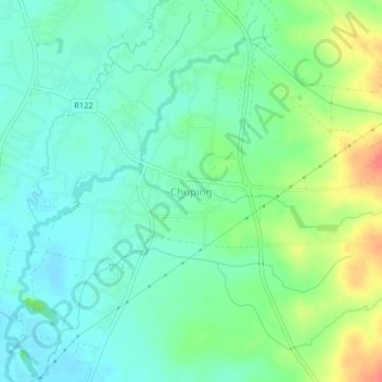
Name: Chuping topographic map, elevation, terrain.

Location: Chuping, Perlis, Malaysia (6.52153 100.27670 6.56153 100.31670)

Average elevation: 121 ft

Minimum elevation: 66 ft

Maximum elevation: 236 ft

Other topographic maps

Click on a map to view its topography, its elevation and its terrain.

Timah Tasoh Reservoir

Malaysia > Perlis

Average elevation: 105 ft

Sungai Batu Pahat

Malaysia > Perlis > Sungai Batu Pahat

Average elevation: 282 ft

View Point Wang Kelian

Malaysia > Perlis

Average elevation: 518 ft

Sungai Tepoh

Malaysia > Perlis > Kangar

Average elevation: 20 ft

Perlis River

Malaysia > Perlis > Kangar

Average elevation: 75 ft

Sungai Kayang

Malaysia > Perlis > Kuala Perlis

Average elevation: 62 ft

Gear up for your next adventure:

🧤Tactile Hiking Gloves - Keep hands warm while operating GPS and smartphone screens
🪶Survival Guide Book - Expert advice for emergency preparedness
🔭Stargazing Telescopes - Perfect for camping in low-light pollution areas shown on maps
🕶️GPS Smartphone Mount - Secure mount for phone navigation
🚪Portable Camp Chair - Foldable chair for comfort at camp

As an Amazon Associate, this site earns from qualifying purchases at no extra cost to you.