
Thank you for supporting this site ❤️
Make a donation
Make a donation
Gear up for your next adventure:
As an Amazon Associate, this site earns from qualifying purchases at no extra cost to you.
Cirque de Gavarnie topographic map
Click on the map to display elevation.
Thank you for supporting this site ❤️
Make a donation
Make a donation
Gear up for your next adventure:
As an Amazon Associate, this site earns from qualifying purchases at no extra cost to you.
About this map
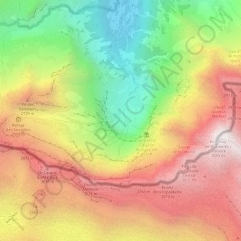
Name: Cirque de Gavarnie topographic map, elevation, terrain.
Average elevation: 7,756 ft
Minimum elevation: 4,662 ft
Maximum elevation: 10,663 ft
Thank you for supporting this site ❤️
Make a donation
Make a donation
Gear up for your next adventure:
As an Amazon Associate, this site earns from qualifying purchases at no extra cost to you.
Other topographic maps
Click on a map to view its topography, its elevation and its terrain.
Hôtellerie du Cirque
France > Occitania > Hautes Pyrenees > Gavarnie-Gèdre > Gavarnie
Average elevation: 6,526 ft