
Thank you for supporting this site ❤️
Make a donation
Make a donation
Gear up for your next adventure:
As an Amazon Associate, this site earns from qualifying purchases at no extra cost to you.
Honaïne topographic map
Click on the map to display elevation.
Thank you for supporting this site ❤️
Make a donation
Make a donation
Gear up for your next adventure:
As an Amazon Associate, this site earns from qualifying purchases at no extra cost to you.
About this map
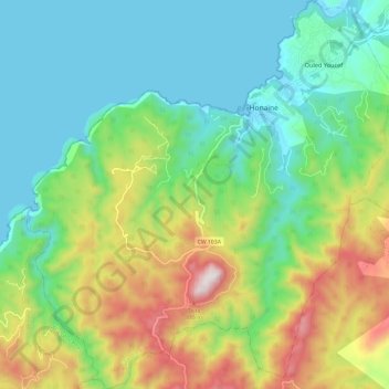
Name: Honaïne topographic map, elevation, terrain.
Location: Honaïne, Daïra de Honaïne, Tlemcen, Algérie (35.10772 -1.72631 35.20519 -1.61344)
Average elevation: 1,004 ft
Minimum elevation: -10 ft
Maximum elevation: 2,805 ft
Thank you for supporting this site ❤️
Make a donation
Make a donation
Gear up for your next adventure:
As an Amazon Associate, this site earns from qualifying purchases at no extra cost to you.