
Make a donation
Gear up for your next adventure:
As an Amazon Associate, this site earns from qualifying purchases at no extra cost to you.
Bagadó topographic map
Click on the map to display elevation.
Make a donation
Gear up for your next adventure:
As an Amazon Associate, this site earns from qualifying purchases at no extra cost to you.
Bagadó
Bagadó es un municipio colombiano ubicado en el departamento de Chocó. Se encuentra a una altitud de 200 m s. n. m. y a 80 km de la capital del departamento, Quibdó. Fue fundado en 1578, y convertido en municipio en 1909. La temperatura promedio es de 28 °C. En el municipio se encuentra el resguardo indígena Andágueda.
Make a donation
Gear up for your next adventure:
As an Amazon Associate, this site earns from qualifying purchases at no extra cost to you.
About this map
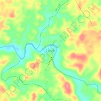
Name: Bagadó topographic map, elevation, terrain.
Location: Bagadó, Chocó, RAP Pacífico, Colombia (5.39169 -76.43597 5.43169 -76.39597)
Average elevation: 430 ft
Minimum elevation: 282 ft
Maximum elevation: 607 ft
Make a donation
Gear up for your next adventure:
As an Amazon Associate, this site earns from qualifying purchases at no extra cost to you.