
Make a donation
Gear up for your next adventure:
As an Amazon Associate, this site earns from qualifying purchases at no extra cost to you.
Chisago City topographic map
Click on the map to display elevation.
Make a donation
Gear up for your next adventure:
As an Amazon Associate, this site earns from qualifying purchases at no extra cost to you.
About this map
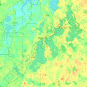
Name: Chisago City topographic map, elevation, terrain.
Location: Chisago City, Chisago County, Minnesota, United States (45.29622 -92.94082 45.43272 -92.86498)
Average elevation: 909 ft
Minimum elevation: 856 ft
Maximum elevation: 988 ft
Chisago County trails, hiking, mountain biking, running and outdoor activities
Make a donation
Gear up for your next adventure:
As an Amazon Associate, this site earns from qualifying purchases at no extra cost to you.
Other topographic maps
Click on a map to view its topography, its elevation and its terrain.
Chain Lake
United States > Minnesota > Chisago County > North Branch > Harris
Average elevation: 922 ft