
Make a donation
Gear up for your next adventure:
As an Amazon Associate, this site earns from qualifying purchases at no extra cost to you.
Curipamba topographic map
Click on the map to display elevation.
Make a donation
Gear up for your next adventure:
As an Amazon Associate, this site earns from qualifying purchases at no extra cost to you.
About this map
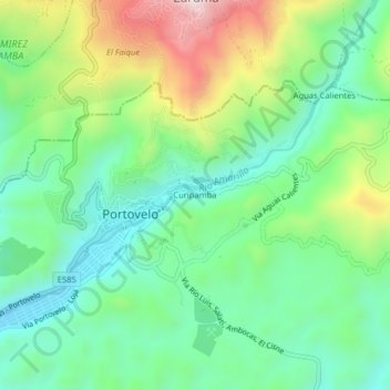
Name: Curipamba topographic map, elevation, terrain.
Location: Curipamba, Portovelo, El Oro, 071153, Ecuador (-3.73324 -79.63056 -3.69324 -79.59056)
Average elevation: 2,595 ft
Minimum elevation: 1,962 ft
Maximum elevation: 3,885 ft
Make a donation
Gear up for your next adventure:
As an Amazon Associate, this site earns from qualifying purchases at no extra cost to you.
Other topographic maps
Click on a map to view its topography, its elevation and its terrain.
Portovelo
Es una región minera, ubicada en las estribaciones de la Cordillera Occidental de los Andes, al pie de la cordillera de Vizcaya y bañada por el Río Amarillo, está situada al sur este de la Provincia de El Oro, a 105 km. de su capital Machala, abarca un área de 35 km. cuadrados. La altitud del cantón…
Average elevation: 2,589 ft