Geolocate

Aguada topographic map

Click on the map to display elevation.

About this map

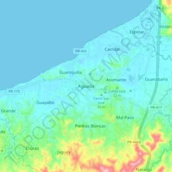
Name: Aguada topographic map, elevation, terrain.

Location: Aguada, Puerto Rico, 00602, United States (18.33977 -67.22875 18.41977 -67.14875)

Average elevation: 102 ft

Minimum elevation: -7 ft

Maximum elevation: 614 ft

Aguada trails, hiking, mountain biking, running and outdoor activities

Gear up for your next adventure:

🪶Paracord Bracelet - Survival bracelet with built‑in tools
🦶Carbon Trekking Poles - Reduce knee impact on steep descents with ultra-light poles
Camping Coffee Makers - Enjoy premium coffee at the summit or campsite
🔪Outdoor Multitools - Essential survival tools for gear repair and field use
🩳Quick‑Dry Hiking Shorts - Comfortable and quick‑dry shorts for summer hiking

As an Amazon Associate, this site earns from qualifying purchases at no extra cost to you.