Geolocate

Kimball topographic map

Click on the map to display elevation.

About this map

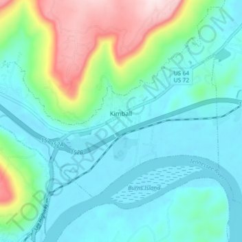
Name: Kimball topographic map, elevation, terrain.

Location: Kimball, Marion County, East Tennessee, Tennessee, United States (35.02751 -85.71456 35.06449 -85.64295)

Average elevation: 886 ft

Minimum elevation: 584 ft

Maximum elevation: 1,926 ft

Marion County trails, hiking, mountain biking, running and outdoor activities

Other topographic maps

Click on a map to view its topography, its elevation and its terrain.

Deadman Eddy

United States > Tennessee > Marion County

Average elevation: 1,165 ft

Haletown

United States > Tennessee > Marion County

Average elevation: 938 ft

Pinhook

United States > Tennessee > Marion County

Average elevation: 997 ft

Raccoon Mountain

United States > Tennessee > Marion County

Average elevation: 1,542 ft

Haletown

United States > Tennessee > Marion County

Average elevation: 938 ft

Ladds

United States > Tennessee > Marion County

Average elevation: 955 ft

Bullhead

United States > Tennessee > Marion County

Average elevation: 1,079 ft

Gear up for your next adventure:

🧴Hand Sanitizer - Keep hands clean while hiking
🛠️Backpacking Tool Kit - Essential toolkit for outdoor repairs
🔊Portable Camp Speaker - Music and alerts at camp
📶Vehicle Signal Boosters - Improve reception in rural areas while driving to trailheads
Backpacking Tents - Weight-optimized shelters for multi-day topographic surveys

As an Amazon Associate, this site earns from qualifying purchases at no extra cost to you.