Hillsboro topographic map
Click on the map to display elevation.
About this map

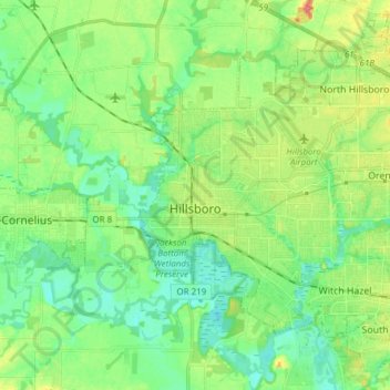
Name: Hillsboro topographic map, elevation, terrain.
Location: Hillsboro, Washington County, Oregon, United States (45.47636 -123.01181 45.57580 -122.85954)
Average elevation: 174 ft
Minimum elevation: 108 ft
Maximum elevation: 305 ft
Hillsboro is located at 45°31′N 122°59′W / 45.517°N 122.983°W / 45.517; -122.983 (Hillsboro, Oregon). The United States Census Bureau reports the city has a total area of 21.6 square miles (55.9 km2), all of which is land. In 2013, Hillsboro itself reported an area of 23.88 square miles (61.8 km2), equivalent to 15,283 acres (61.8 km2). The city is located in the Tualatin Valley, and the Tualatin River forms part of the southern city limits. The city's terrain is fairly level, consistent with an agricultural past and the farms still in operation. Hillsboro is about 17 miles (27 km) west of Portland and immediately west of Beaverton, at an elevation of 194 feet (59 m) above sea level. In addition to the Tualatin River, streams include Dairy Creek, McKay Creek, Rock Creek, Dawson Creek, and Turner Creek. Neighboring communities in addition to Beaverton are Aloha, Cornelius, Glencoe, North Plains, Reedville, Scholls, and West Union.
Other topographic maps
Click on a map to view its topography, its elevation and its terrain.

Beaverton
United States > Oregon > Washington County
Beaverton, Washington County, Oregon, United States
Average elevation: 348 ft

Tigard
United States > Oregon > Washington County
Tigard, Washington County, Oregon, United States
Average elevation: 272 ft

Forest Grove
United States > Oregon > Washington County
Forest Grove, Washington County, Oregon, 97116, United States
Average elevation: 203 ft

Sherwood
United States > Oregon > Washington County
Sherwood, Washington County, Oregon, 97140, United States
Average elevation: 223 ft

Banks
United States > Oregon > Washington County
Banks, Washington County, Oregon, 97106, United States
Average elevation: 230 ft

North Plains
United States > Oregon > Washington County
North Plains, Washington County, Oregon, United States
Average elevation: 187 ft

Rock Creek
United States > Oregon > Washington County
Rock Creek, Washington County, Oregon, United States
Average elevation: 213 ft

Chehalem
United States > Oregon > Washington County
Chehalem, Washington County, Oregon, 97140, United States
Average elevation: 594 ft

Vose
United States > Oregon > Washington County > Beaverton
Vose, Beaverton, Washington County, Oregon, United States
Average elevation: 230 ft

Denney Whitford/Raleigh West
United States > Oregon > Washington County > Beaverton
Denney Whitford/Raleigh West, Beaverton, Washington County, Oregon, United States
Average elevation: 236 ft

Cornelius
United States > Oregon > Washington County
Cornelius, Washington County, Oregon, United States
Average elevation: 167 ft

King City
United States > Oregon > Washington County
King City, Washington County, Oregon, United States
Average elevation: 243 ft

L.L. Stub Stewart State Park
United States > Oregon > Washington County
L.L. Stub Stewart State Park, Service Road, Washington County, Oregon, 97109, United States
Average elevation: 981 ft

Tualatin
United States > Oregon > Washington County
Tualatin, Washington County, Oregon, 97062, United States
Average elevation: 230 ft

Pendelton Creek
United States > Oregon > Washington County > Portland
Pendelton Creek, Raleigh Hills, Portland, Washington County, Oregon, 97221, United States
Average elevation: 328 ft

Timber
United States > Oregon > Washington County
Timber, Washington County, Oregon, 97144, United States
Average elevation: 1,047 ft