Geolocate

Endon Bank topographic map

Click on the map to display elevation.

About this map

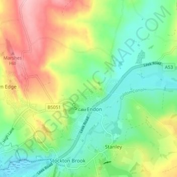
Name: Endon Bank topographic map, elevation, terrain.

Location: Endon Bank, Endon and Stanley, Endon, Staffordshire Moorlands, Staffordshire, England, ST9 9HP, United Kingdom (53.06154 -2.13350 53.10154 -2.09350)

Average elevation: 630 ft

Minimum elevation: 436 ft

Maximum elevation: 938 ft

Other topographic maps

Click on a map to view its topography, its elevation and its terrain.

Gear up for your next adventure:

🎁Geography Themed Gifts - Unique gift ideas for map lovers and geography enthusiasts
🪶Survival Guide Book - Expert advice for emergency preparedness
🛏️Cold Weather Sleeping Bag - Warm sleeping bag for cold conditions
🔭Stargazing Telescopes - Perfect for camping in low-light pollution areas shown on maps
🎒Day Hiking Backpack - Lightweight backpack perfect for day trips and outdoor adventures

As an Amazon Associate, this site earns from qualifying purchases at no extra cost to you.