
Make a donation
Gear up for your next adventure:
As an Amazon Associate, this site earns from qualifying purchases at no extra cost to you.
Lac des Gloriettes topographic map
Click on the map to display elevation.
Make a donation
Gear up for your next adventure:
As an Amazon Associate, this site earns from qualifying purchases at no extra cost to you.
About this map
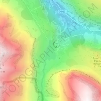
Name: Lac des Gloriettes topographic map, elevation, terrain.
Average elevation: 6,289 ft
Minimum elevation: 4,377 ft
Maximum elevation: 8,468 ft
Make a donation
Gear up for your next adventure:
As an Amazon Associate, this site earns from qualifying purchases at no extra cost to you.
Other topographic maps
Click on a map to view its topography, its elevation and its terrain.
Cirque de Troumouse
France > Occitanie > Hautes-Pyrénées > Gavarnie-Gèdre > Gèdre
Average elevation: 8,041 ft
Biroulet
France > Occitanie > Hautes-Pyrénées > Gavarnie-Gèdre > Gèdre > Saussa-Debat
Average elevation: 4,419 ft
Make a donation
Gear up for your next adventure:
As an Amazon Associate, this site earns from qualifying purchases at no extra cost to you.
Saussa-Debat
France > Occitanie > Hautes-Pyrénées > Gavarnie-Gèdre > Gèdre
Average elevation: 4,879 ft