
Thank you for supporting this site ❤️
Make a donation
Make a donation
Gear up for your next adventure:
As an Amazon Associate, this site earns from qualifying purchases at no extra cost to you.
Wislikofen topographic map
Click on the map to display elevation.
Thank you for supporting this site ❤️
Make a donation
Make a donation
Gear up for your next adventure:
As an Amazon Associate, this site earns from qualifying purchases at no extra cost to you.
About this map
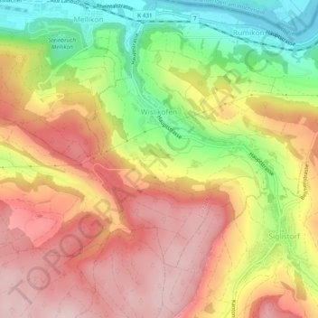
Name: Wislikofen topographic map, elevation, terrain.
Location: Wislikofen, Zurzach, Bezirk Zurzach, Aargau, 5463, Schweiz (47.54219 8.34470 47.56399 8.39202)
Average elevation: 1,568 ft
Minimum elevation: 1,079 ft
Maximum elevation: 1,969 ft
Thank you for supporting this site ❤️
Make a donation
Make a donation
Gear up for your next adventure:
As an Amazon Associate, this site earns from qualifying purchases at no extra cost to you.