
Make a donation
Gear up for your next adventure:
As an Amazon Associate, this site earns from qualifying purchases at no extra cost to you.
Philippsthal (Werra) topographic map
Click on the map to display elevation.
Make a donation
Gear up for your next adventure:
As an Amazon Associate, this site earns from qualifying purchases at no extra cost to you.
Philippsthal (Werra)
Der tiefste Punkt liegt mit 212 m ü. NN in der Werraaue bei Harnrode. Der höchste Punkt liegt im Nordosten der Gemeindegemarkung auf etwa 445 m ü. NN Höhe, wo die Gemarkungsgrenzen von Philippsthal, Heringen und Vacha aufeinandertreffen.
Make a donation
Gear up for your next adventure:
As an Amazon Associate, this site earns from qualifying purchases at no extra cost to you.
About this map
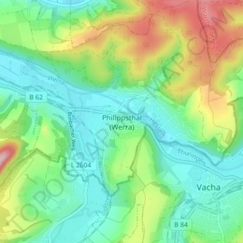
Name: Philippsthal (Werra) topographic map, elevation, terrain.
Average elevation: 945 ft
Minimum elevation: 705 ft
Maximum elevation: 1,463 ft
Make a donation
Gear up for your next adventure:
As an Amazon Associate, this site earns from qualifying purchases at no extra cost to you.