
Make a donation
Gear up for your next adventure:
As an Amazon Associate, this site earns from qualifying purchases at no extra cost to you.
El Mouradia topographic map
Click on the map to display elevation.
Make a donation
Gear up for your next adventure:
As an Amazon Associate, this site earns from qualifying purchases at no extra cost to you.
About this map
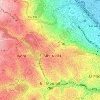
Name: El Mouradia topographic map, elevation, terrain.
Location: El Mouradia, Sidi M'Hamed District, Algiers, Algeria (36.73941 3.03421 36.75864 3.05948)
Average elevation: 427 ft
Minimum elevation: -3 ft
Maximum elevation: 774 ft
Make a donation
Gear up for your next adventure:
As an Amazon Associate, this site earns from qualifying purchases at no extra cost to you.
Other topographic maps
Click on a map to view its topography, its elevation and its terrain.
Algiers
Algeria > Algiers > Sidi M'Hamed District
Algiers was a walled city from the time of the deys until the close of the 19th century. The French, after their occupation of the city (1830), built a rampart, parapet and ditch, with two terminal forts, Bab Azoun باب عزون to the south and Bab-el-Oued اد to the north. The forts and part of the…
Average elevation: 148 ft
Make a donation
Gear up for your next adventure:
As an Amazon Associate, this site earns from qualifying purchases at no extra cost to you.
Algiers
Algeria > Algiers > Sidi M'Hamed District
Algiers was a walled city from the time of the deys until the close of the 19th century. The French, after their occupation of the city (1830), built a rampart, parapet and ditch, with two terminal forts, Bab Azoun باب عزون to the south and Bab-el-Oued اد to the north. The forts and part of the…
Average elevation: 148 ft
Algiers
Algeria > Algiers > Sidi M'Hamed District > Alger-Centre
The city contains the largest infrastructure facilities in the country; railway and highway connections with neighbouring cities and international links via the Houari Boumediene Airport and Algiers Ferry Terminal. Algiers possesses notable mass transit options, that includes the Algiers Metro, the city's…
Average elevation: 148 ft
Algiers
Algeria > Algiers > Sidi M'Hamed District > Alger-Centre
The city's downtown sits at an elevation of 2 m (at the Algiers Central Post Office), while it averages 45 m across the city's metropolitan area, and tops at 407 m on the Bouzaréah peak. Algiers Province, the administrative area that includes the city's urban and suburban centers covers 1,190 km2 (460 sq mi).
Average elevation: 148 ft
Algiers
Algeria > Algiers > Sidi M'Hamed District > Alger-Centre
Algiers was a walled city from the time of the deys until the close of the 19th century. The French, after their occupation of the city (1830), built a rampart, parapet and ditch, with two terminal forts, Bab Azoun باب عزون to the south and Bab-el-Oued اد to the north. The forts and part of the…
Average elevation: 148 ft
Make a donation
Gear up for your next adventure:
As an Amazon Associate, this site earns from qualifying purchases at no extra cost to you.
Algiers
Algeria > Algiers > Sidi M'Hamed District
Algiers was a walled city from the time of the deys until the close of the 19th century. The French, after their occupation of the city (1830), built a rampart, parapet and ditch, with two terminal forts, Bab Azoun باب عزون to the south and Bab-el-Oued اد to the north. The forts and part of the…
Average elevation: 148 ft
Algiers
Algeria > Algiers > Sidi M'Hamed District > Alger-Centre
Algiers was a walled city from the time of the deys until the close of the 19th century. The French, after their occupation of the city (1830), built a rampart, parapet and ditch, with two terminal forts, Bab Azoun باب عزون to the south and Bab-el-Oued اد to the north. The forts and part of the…
Average elevation: 148 ft
El Madania
Algeria > Algiers > Sidi M'Hamed District > El Madania > El Madania
Average elevation: 295 ft