
Make a donation
Gear up for your next adventure:
As an Amazon Associate, this site earns from qualifying purchases at no extra cost to you.
Gerland topographic map
Click on the map to display elevation.
Make a donation
Gear up for your next adventure:
As an Amazon Associate, this site earns from qualifying purchases at no extra cost to you.
About this map
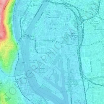
Name: Gerland topographic map, elevation, terrain.
Average elevation: 581 ft
Minimum elevation: 528 ft
Maximum elevation: 1,014 ft
Make a donation
Gear up for your next adventure:
As an Amazon Associate, this site earns from qualifying purchases at no extra cost to you.
Other topographic maps
Click on a map to view its topography, its elevation and its terrain.
Parc de la Tête d'Or
France > Auvergne-Rhône-Alpes > Métropole de Lyon > Lyon
Average elevation: 620 ft
Jardin Guylaine Gouzou-Testud
France > Auvergne-Rhône-Alpes > Métropole de Lyon > Lyon
Average elevation: 692 ft
Make a donation
Gear up for your next adventure:
As an Amazon Associate, this site earns from qualifying purchases at no extra cost to you.