Geolocate

Omalur topographic map

Click on the map to display elevation.

Omalur

Omalur is located at 11°44′N 78°04′E / 11.73°N 78.07°E / 11.73; 78.07. It has an average elevation of 298 metres (977 feet).

Wikipedia (CC-BY-SA 3.0)

About this map

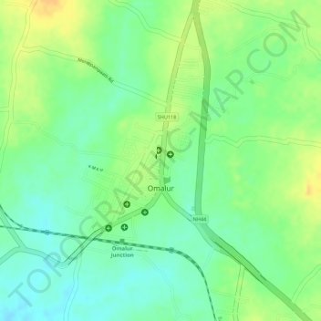
Name: Omalur topographic map, elevation, terrain.

Location: Omalur, Salem, Tamil Nadu, 636455, India (11.73906 78.04216 11.75149 78.05331)

Average elevation: 912 ft

Minimum elevation: 863 ft

Maximum elevation: 965 ft

Gear up for your next adventure:

🌐World Map Poster - Decorative world maps with topographic info
⛑️Personal Locator Beacon - Safety beacon for emergencies
🌎3D Topographic Globes - Raised relief globes for a tactile understanding of geography
💧Water Purification System - Clean water on the trail with reliable purifiers
🏫Relief Map Kits - Hands-on tools for teaching landforms and elevation

As an Amazon Associate, this site earns from qualifying purchases at no extra cost to you.