Geolocate

Pierpont topographic map

Click on the map to display elevation.

About this map

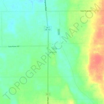
Name: Pierpont topographic map, elevation, terrain.

Location: Pierpont, Ashtabula County, Ohio, 44082, United States (41.72922 -80.58841 41.76922 -80.54841)

Average elevation: 1,007 ft

Minimum elevation: 938 ft

Maximum elevation: 1,112 ft

Ashtabula County trails, hiking, mountain biking, running and outdoor activities

Other topographic maps

Click on a map to view its topography, its elevation and its terrain.

Jefferson

United States > Ohio > Ashtabula County

Average elevation: 935 ft

Roaming Shores

United States > Ohio > Ashtabula County

Average elevation: 883 ft

Rock Creek

United States > Ohio > Ashtabula County

Average elevation: 814 ft

Edgewood

United States > Ohio > Ashtabula County

Average elevation: 702 ft

North Kingsville

United States > Ohio > Ashtabula County

Average elevation: 650 ft

New Lyme Township

United States > Ohio > Ashtabula County

Average elevation: 994 ft

Ashtabula

United States > Ohio > Ashtabula County

Average elevation: 656 ft

Conneaut

United States > Ohio > Ashtabula County

Average elevation: 696 ft

Geneva

United States > Ohio > Ashtabula County

Average elevation: 591 ft

Gear up for your next adventure:

🎒Day Hiking Backpack - Lightweight backpack perfect for day trips and outdoor adventures
🎒Trail Energy Bars - High‑calorie bars for hiking energy
🦶Carbon Trekking Poles - Reduce knee impact on steep descents with ultra-light poles
📦Gear Storage Bags - Organize and protect outdoor equipment
🥇GPS Hiking Watch - Multi‑sport GPS watch with navigation and trail tracking

As an Amazon Associate, this site earns from qualifying purchases at no extra cost to you.