Geolocate

Ashtabula topographic map

Click on the map to display elevation.

About this map

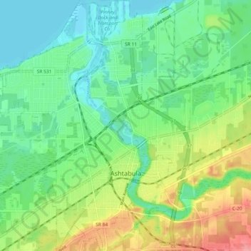
Name: Ashtabula topographic map, elevation, terrain.

Location: Ashtabula, Ashtabula County, Ohio, 44004, United States (41.84358 -80.83720 41.91178 -80.76721)

Average elevation: 663 ft

Minimum elevation: 561 ft

Maximum elevation: 863 ft

Ashtabula County trails, hiking, mountain biking, running and outdoor activities

Other topographic maps

Click on a map to view its topography, its elevation and its terrain.

Phelps Creek

United States > Ohio > Ashtabula County

Average elevation: 1,070 ft

Chapel

United States > Ohio > Ashtabula County

Average elevation: 846 ft

Pierpont

United States > Ohio > Ashtabula County

Average elevation: 1,001 ft

Kingsville

United States > Ohio > Ashtabula County

Average elevation: 741 ft

Gear up for your next adventure:

Backpacking Tent - Lightweight and durable tent for multi‑day hikes
🥾Hiking Shoes - Durable and comfortable shoes for trail hiking
🥤Water Filter Bottle - All‑in‑one filter bottle for safe hydration
📷Action Camera - Capture your outdoor adventures in HD
GPS Sports Watch - GPS watch for running, hiking and training

As an Amazon Associate, this site earns from qualifying purchases at no extra cost to you.