Geolocate

Wheatland topographic map

Click on the map to display elevation.

About this map

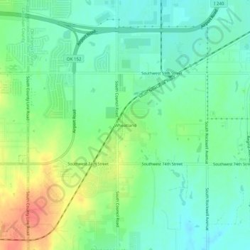
Name: Wheatland topographic map, elevation, terrain.

Location: Wheatland, Oklahoma City, Oklahoma County, Oklahoma, 73097, United States (35.37784 -97.67226 35.41784 -97.63226)

Average elevation: 1,306 ft

Minimum elevation: 1,247 ft

Maximum elevation: 1,414 ft

Oklahoma County trails, hiking, mountain biking, running and outdoor activities

Other topographic maps

Click on a map to view its topography, its elevation and its terrain.

University

United States > Oklahoma > Oklahoma County > Oklahoma City

Average elevation: 1,237 ft

Lake Hefner

United States > Oklahoma > Oklahoma County > Oklahoma City

Average elevation: 1,207 ft

Gear up for your next adventure:

📻Weather Alert Radios - Stay informed of storm risks while off-the-grid
🪶Thermal Camp Blanket - Extra warmth for cold nights
🚑Emergency Bivvies - Heat-reflective sleeping bags for survival situations
🕶️GPS Smartphone Mount - Secure mount for phone navigation
🔋Rechargeable Batteries - Power up your outdoor devices

As an Amazon Associate, this site earns from qualifying purchases at no extra cost to you.