Geolocate

Alston topographic map

Click on the map to display elevation.

About this map

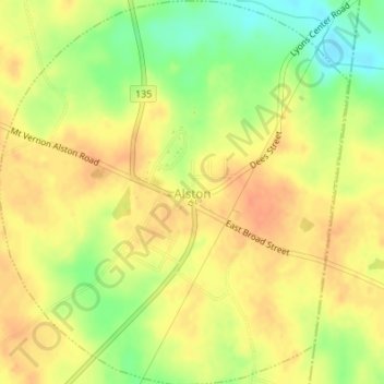
Name: Alston topographic map, elevation, terrain.

Location: Alston, Montgomery County, Georgia, 30412, United States (32.06638 -82.49476 32.09523 -82.46379)

Average elevation: 230 ft

Minimum elevation: 144 ft

Maximum elevation: 279 ft

Montgomery County trails, hiking, mountain biking, running and outdoor activities

Other topographic maps

Click on a map to view its topography, its elevation and its terrain.

Kibbee

United States > Georgia > Montgomery County

Average elevation: 285 ft

Gear up for your next adventure:

🕶️GPS Smartphone Mount - Secure mount for phone navigation
🪶Wildlife Field Guides - Learn animal tracking and species ID
🪶Camp Gear Gift Set - Perfect gift bundle for outdoor fans
🪓Survival Multi‑Tool - Versatile tool for camp and trail tasks
Solar GPS Watches - Advanced multisport watches with built-in topographic maps

As an Amazon Associate, this site earns from qualifying purchases at no extra cost to you.