Geolocate

Manche topographic map

Click on the map to display elevation.

👉 Easily get elevation data in JSON, GeoTIFF and KML formats using Elevation API
Thank you for supporting this site ❤️
Make a donation

Gear up for your next adventure:

As an Amazon Associate, this site earns from qualifying purchases at no extra cost to you.

About this map

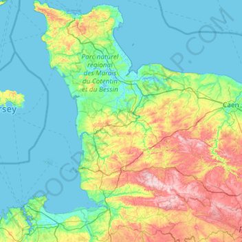
Name: Manche topographic map, elevation, terrain.

Location: Manche, Normandy, Metropolitan France, France (48.45580 -1.95506 49.72801 -0.73484)

Average elevation: 207 ft

Minimum elevation: -7 ft

Maximum elevation: 1,188 ft

Other topographic maps

Click on a map to view its topography, its elevation and its terrain.

Dany

France > Normandy > Orne > Le Ménil-Scelleur

Average elevation: 817 ft

Le Domaine

France > Normandy > Calvados > Vire Normandie > Le Domaine

Average elevation: 515 ft

La Douveterie

France > Normandy > Manche > La Lucerne-d'Outremer

Average elevation: 351 ft

Gear up for your next adventure:

🧯Emergency Survival Kit - All‑in‑one survival essentials for the backcountry
🪶Thermal Camp Blanket - Extra warmth for cold nights
🥄Camping Utensil Set - Lightweight utensils for outdoor meals
🔊Portable Camp Speaker - Music and alerts at camp
🏫Relief Map Kits - Hands-on tools for teaching landforms and elevation

As an Amazon Associate, this site earns from qualifying purchases at no extra cost to you.