
Make a donation
Gear up for your next adventure:
As an Amazon Associate, this site earns from qualifying purchases at no extra cost to you.
Hugo topographic map
Click on the map to display elevation.
Make a donation
Gear up for your next adventure:
As an Amazon Associate, this site earns from qualifying purchases at no extra cost to you.
Hugo
According to the United States Census Bureau, the town has a total area of 1.0 square mile (2.6 km2), all of which is land. Hugo's elevation is 5,039 ft.
Make a donation
Gear up for your next adventure:
As an Amazon Associate, this site earns from qualifying purchases at no extra cost to you.
About this map
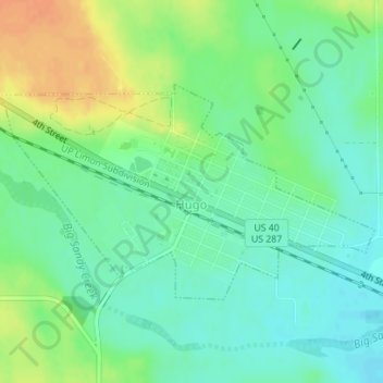
Name: Hugo topographic map, elevation, terrain.
Location: Hugo, Lincoln County, Colorado, 80821, United States (39.12789 -103.48933 39.14310 -103.45472)
Average elevation: 5,062 ft
Minimum elevation: 5,013 ft
Maximum elevation: 5,141 ft
Lincoln County trails, hiking, mountain biking, running and outdoor activities
Make a donation
Gear up for your next adventure:
As an Amazon Associate, this site earns from qualifying purchases at no extra cost to you.