
Make a donation
Gear up for your next adventure:
As an Amazon Associate, this site earns from qualifying purchases at no extra cost to you.
Loenhout topographic map
Click on the map to display elevation.
Make a donation
Gear up for your next adventure:
As an Amazon Associate, this site earns from qualifying purchases at no extra cost to you.
Loenhout
Loenhout ligt in de Noorderkempen. Het is een vlak gebied met een hoogte van 13-22 meter. Vanuit het zuiden lopen een aantal beken in noordelijke richting, waarvan de Kleine Aa de belangrijkste is. Ter hoogte van de Belgisch-Nederlandse grens komen deze beken bij elkaar om de Aa of Weerijs te vormen.
Make a donation
Gear up for your next adventure:
As an Amazon Associate, this site earns from qualifying purchases at no extra cost to you.
About this map
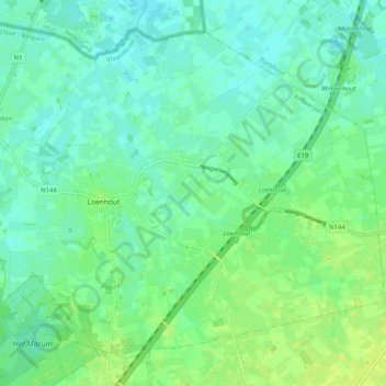
Name: Loenhout topographic map, elevation, terrain.
Location: Loenhout, Wuustwezel, Antwerpen, Vlaanderen, België (51.37305 4.61604 51.42689 4.71698)
Average elevation: 52 ft
Minimum elevation: 33 ft
Maximum elevation: 75 ft
Make a donation
Gear up for your next adventure:
As an Amazon Associate, this site earns from qualifying purchases at no extra cost to you.