Geolocate

Rawang topographic map

Click on the map to display elevation.

About this map

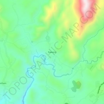
Name: Rawang topographic map, elevation, terrain.

Location: Rawang, Tanay, Rizal, Calabarzon, 1980, Philippines (14.52577 121.29630 14.56577 121.33630)

Average elevation: 699 ft

Minimum elevation: 148 ft

Maximum elevation: 1,949 ft

Other topographic maps

Click on a map to view its topography, its elevation and its terrain.

Tanay River

Philippines > Rizal > Tanay > Little Ville

Average elevation: 112 ft

Gear up for your next adventure:

🏕️Family Camping Gear - Essentials for group camping trips
🏥Hiking First Aid Kits - Comprehensive medical kits for remote trail injuries
🕶️Glacier Sunglasses - Side shields to protect eyes from high-altitude snow glare
🛏️Cold Weather Sleeping Bag - Warm sleeping bag for cold conditions
📚USA Hiking Guide Books - Top trail guides and map books

As an Amazon Associate, this site earns from qualifying purchases at no extra cost to you.