
Make a donation
Gear up for your next adventure:
As an Amazon Associate, this site earns from qualifying purchases at no extra cost to you.
Finistère topographic map
Click on the map to display elevation.
Make a donation
Gear up for your next adventure:
As an Amazon Associate, this site earns from qualifying purchases at no extra cost to you.
About this map
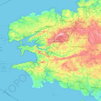
Name: Finistère topographic map, elevation, terrain.
Location: Finistère, Brittany, Metropolitan France, France (47.70128 -5.14403 48.75719 -3.38665)
Average elevation: 226 ft
Minimum elevation: -3 ft
Maximum elevation: 1,234 ft
Make a donation
Gear up for your next adventure:
As an Amazon Associate, this site earns from qualifying purchases at no extra cost to you.
Other topographic maps
Click on a map to view its topography, its elevation and its terrain.
Make a donation
Gear up for your next adventure:
As an Amazon Associate, this site earns from qualifying purchases at no extra cost to you.
Moulin de Bel Air
France > Brittany > Finistère > Brélès > Moulin de Bel Air
Average elevation: 131 ft