
Make a donation
Gear up for your next adventure:
As an Amazon Associate, this site earns from qualifying purchases at no extra cost to you.
Anekal topographic map
Click on the map to display elevation.
Make a donation
Gear up for your next adventure:
As an Amazon Associate, this site earns from qualifying purchases at no extra cost to you.
Anekal
Anekal is located at 12°42′N 77°42′E / 12.7°N 77.7°E / 12.7; 77.7. It has an average elevation of 915 metres (3001 feet).
Make a donation
Gear up for your next adventure:
As an Amazon Associate, this site earns from qualifying purchases at no extra cost to you.
About this map
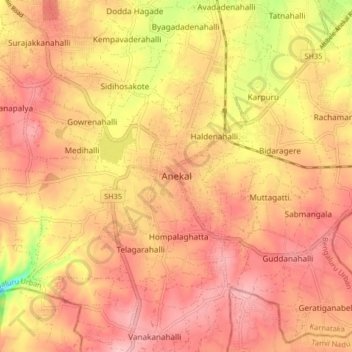
Name: Anekal topographic map, elevation, terrain.
Location: Anekal, Bengaluru Urban, Karnataka, 562106, India (12.66864 77.65940 12.74864 77.73940)
Average elevation: 3,025 ft
Minimum elevation: 2,697 ft
Maximum elevation: 3,179 ft
Make a donation
Gear up for your next adventure:
As an Amazon Associate, this site earns from qualifying purchases at no extra cost to you.
Other topographic maps
Click on a map to view its topography, its elevation and its terrain.
Make a donation
Gear up for your next adventure:
As an Amazon Associate, this site earns from qualifying purchases at no extra cost to you.