
Make a donation
Gear up for your next adventure:
As an Amazon Associate, this site earns from qualifying purchases at no extra cost to you.
Sant Joan de Labritja topographic map
Click on the map to display elevation.
Make a donation
Gear up for your next adventure:
As an Amazon Associate, this site earns from qualifying purchases at no extra cost to you.
About this map
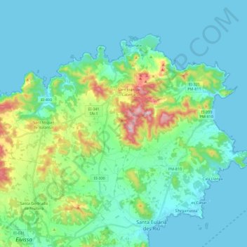
Name: Sant Joan de Labritja topographic map, elevation, terrain.
Location: Sant Joan de Labritja, Ibiza, Îles Baléares, Espagne (38.99296 1.38919 39.11841 1.61138)
Average elevation: 240 ft
Minimum elevation: -7 ft
Maximum elevation: 1,299 ft
Make a donation
Gear up for your next adventure:
As an Amazon Associate, this site earns from qualifying purchases at no extra cost to you.
Other topographic maps
Click on a map to view its topography, its elevation and its terrain.
Sant Francesc de s'Estany
Espagne > Îles Baléares > Ibiza > Sant Josep de sa Talaia
Sa Talaia (qui a donné son nom au village) est une montagne couverte de pins qui avec ses 475 m d'altitude est le point le plus haut de l'île.
Average elevation: 43 ft
Make a donation
Gear up for your next adventure:
As an Amazon Associate, this site earns from qualifying purchases at no extra cost to you.