
Puipuren topographic map
Interactive map
Click on the map to display elevation.
About this map
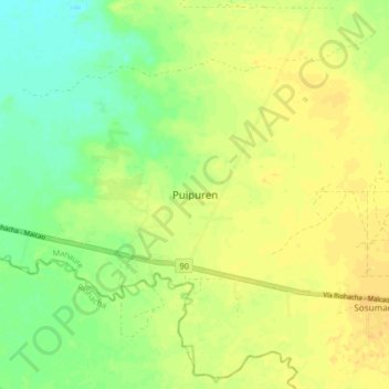
Name: Puipuren topographic map, elevation, terrain.
Location: Puipuren, Manaure, La Guajira, RAP Caribe, Colombia (11.48425 -72.82499 11.56425 -72.74499)
Average elevation: 49 ft
Minimum elevation: -3 ft
Maximum elevation: 79 ft
Other topographic maps
Click on a map to view its topography, its elevation and its terrain.
Iyospa
Colombia > La Guajira > Manaure
Iyospa, Manaure, La Guajira, RAP Caribe, Colombia
Average elevation: 75 ft