
Make a donation
Gear up for your next adventure:
As an Amazon Associate, this site earns from qualifying purchases at no extra cost to you.
Humboldt/Gremberg topographic map
Click on the map to display elevation.
Make a donation
Gear up for your next adventure:
As an Amazon Associate, this site earns from qualifying purchases at no extra cost to you.
Humboldt/Gremberg
Brück | Höhenberg | Humboldt/Gremberg | Kalk | Merheim | Neubrück | Ostheim | Rath/Heumar | Vingst
Make a donation
Gear up for your next adventure:
As an Amazon Associate, this site earns from qualifying purchases at no extra cost to you.
About this map
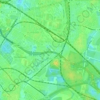
Name: Humboldt/Gremberg topographic map, elevation, terrain.
Location: Humboldt/Gremberg, Kalk, Köln, Nordrhein-Westfalen, Deutschland (50.91416 6.98696 50.93712 7.03301)
Average elevation: 164 ft
Minimum elevation: 131 ft
Maximum elevation: 197 ft
Make a donation
Gear up for your next adventure:
As an Amazon Associate, this site earns from qualifying purchases at no extra cost to you.
Other topographic maps
Click on a map to view its topography, its elevation and its terrain.
Make a donation
Gear up for your next adventure:
As an Amazon Associate, this site earns from qualifying purchases at no extra cost to you.