Geolocate

Pomezia topographic map

Click on the map to display elevation.

About this map

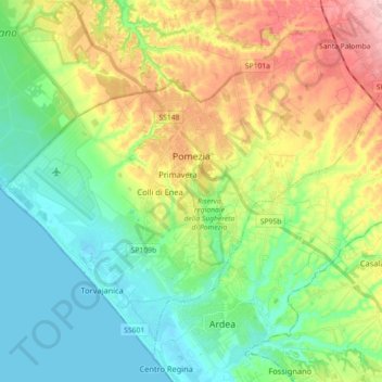
Name: Pomezia topographic map, elevation, terrain.

Location: Pomezia, Roma Capitale, Lazio, 00071, Italy (41.59579 12.41594 41.71446 12.59548)

Average elevation: 177 ft

Minimum elevation: -3 ft

Maximum elevation: 505 ft

Other topographic maps

Click on a map to view its topography, its elevation and its terrain.

Tivoli Terme

Italy > Lazio > Roma Capitale

Average elevation: 217 ft

Lido di Ostia

Italy > Lazio > Roma Capitale > Rome

Average elevation: 7 ft

Gear up for your next adventure:

Backpacking Tents - Weight-optimized shelters for multi-day topographic surveys
Solar GPS Watches - Advanced multisport watches with built-in topographic maps
🌡️Handheld Weather Meters - Measure wind, temp, and pressure for safe mountain travel
🪄Magnetic Compass - Accurate compass for navigation
Camping Coffee Makers - Enjoy premium coffee at the summit or campsite

As an Amazon Associate, this site earns from qualifying purchases at no extra cost to you.