Geolocate

Adrian topographic map

Click on the map to display elevation.

About this map

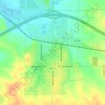
Name: Adrian topographic map, elevation, terrain.

Location: Adrian, Nobles County, Minnesota, United States (43.62345 -95.94514 43.64519 -95.91411)

Average elevation: 1,565 ft

Minimum elevation: 1,506 ft

Maximum elevation: 1,637 ft

Nobles County trails, hiking, mountain biking, running and outdoor activities

Gear up for your next adventure:

🧷Carabiner Set - Durable clips for gear attachment
🧢Outdoor Hiking Hat - Sun protection hat for outdoor explorers
🪓Survival Multi‑Tool - Versatile tool for camp and trail tasks
🩳Quick‑Dry Hiking Shorts - Comfortable and quick‑dry shorts for summer hiking
🥾Men's Hiking Boots - Durable, waterproof footwear for rugged terrain and steep inclines

As an Amazon Associate, this site earns from qualifying purchases at no extra cost to you.