
Make a donation
Gear up for your next adventure:
As an Amazon Associate, this site earns from qualifying purchases at no extra cost to you.
Nová Kelča topographic map
Click on the map to display elevation.
Make a donation
Gear up for your next adventure:
As an Amazon Associate, this site earns from qualifying purchases at no extra cost to you.
Nová Kelča
The municipality lies at an altitude of 180 metres and covers an area of 11.836 km². It has a population of about 355 people.
Make a donation
Gear up for your next adventure:
As an Amazon Associate, this site earns from qualifying purchases at no extra cost to you.
About this map
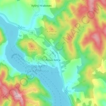
Name: Nová Kelča topographic map, elevation, terrain.
Average elevation: 755 ft
Minimum elevation: 505 ft
Maximum elevation: 1,237 ft
Make a donation
Gear up for your next adventure:
As an Amazon Associate, this site earns from qualifying purchases at no extra cost to you.
Other topographic maps
Click on a map to view its topography, its elevation and its terrain.
Jasina od Šťavia
Slovakia > Region of Prešov > District of Vranov nad Topľou > Rudlov
Average elevation: 1,965 ft