
Make a donation
Gear up for your next adventure:
As an Amazon Associate, this site earns from qualifying purchases at no extra cost to you.
Polokwane topographic map
Click on the map to display elevation.
Make a donation
Gear up for your next adventure:
As an Amazon Associate, this site earns from qualifying purchases at no extra cost to you.
About this map
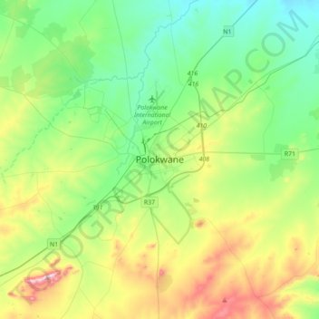
Name: Polokwane topographic map, elevation, terrain.
Average elevation: 4,281 ft
Minimum elevation: 3,773 ft
Maximum elevation: 5,495 ft
Make a donation
Gear up for your next adventure:
As an Amazon Associate, this site earns from qualifying purchases at no extra cost to you.
Other topographic maps
Click on a map to view its topography, its elevation and its terrain.
Lepelle-Nkumpi Local Municipality
South Africa > Limpopo > Capricorn District Municipality
Average elevation: 3,720 ft
Blouberg Local Municipality
South Africa > Limpopo > Capricorn District Municipality
Average elevation: 2,910 ft
Molemole Local Municipality
South Africa > Limpopo > Capricorn District Municipality
Average elevation: 3,556 ft
Polokwane Local Municipality
South Africa > Limpopo > Capricorn District Municipality
Average elevation: 4,190 ft
Make a donation
Gear up for your next adventure:
As an Amazon Associate, this site earns from qualifying purchases at no extra cost to you.
Wolkberg Forest Wilderness Area
South Africa > Limpopo > Capricorn District Municipality > Lepelle-Nkumpi Local Municipality
Average elevation: 4,068 ft
Aganang Local Municipality
South Africa > Limpopo > Capricorn District Municipality
Average elevation: 3,750 ft
Lepelle-Nkumpi Local Municipality
South Africa > Limpopo > Capricorn District Municipality
Average elevation: 3,720 ft
Polokwane Ward 1
South Africa > Limpopo > Capricorn District Municipality > Polokwane Local Municipality
Average elevation: 4,446 ft
Make a donation
Gear up for your next adventure:
As an Amazon Associate, this site earns from qualifying purchases at no extra cost to you.
Molemole Local Municipality
South Africa > Limpopo > Capricorn District Municipality
Average elevation: 3,556 ft
Blouberg Local Municipality
South Africa > Limpopo > Capricorn District Municipality
Average elevation: 2,910 ft
Blouberg Local Municipality
South Africa > Limpopo > Capricorn District Municipality
Average elevation: 2,910 ft
Blouberg Local Municipality
South Africa > Limpopo > Capricorn District Municipality
Average elevation: 2,910 ft
Make a donation
Gear up for your next adventure:
As an Amazon Associate, this site earns from qualifying purchases at no extra cost to you.
Blouberg Local Municipality
South Africa > Limpopo > Capricorn District Municipality
Average elevation: 2,910 ft