
Make a donation
Gear up for your next adventure:
As an Amazon Associate, this site earns from qualifying purchases at no extra cost to you.
Aganang Local Municipality topographic map
Click on the map to display elevation.
Make a donation
Gear up for your next adventure:
As an Amazon Associate, this site earns from qualifying purchases at no extra cost to you.
About this map
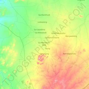
Name: Aganang Local Municipality topographic map, elevation, terrain.
Average elevation: 3,750 ft
Minimum elevation: 2,884 ft
Maximum elevation: 5,663 ft
Make a donation
Gear up for your next adventure:
As an Amazon Associate, this site earns from qualifying purchases at no extra cost to you.
Other topographic maps
Click on a map to view its topography, its elevation and its terrain.
Lebowakgomo
South Africa > Limpopo > Capricorn District Municipality > Lepelle-Nkumpi Local Municipality
Average elevation: 3,337 ft
Ga-Molepo
South Africa > Limpopo > Capricorn District Municipality > Polokwane Local Municipality
Average elevation: 4,236 ft
Mankweng
South Africa > Limpopo > Capricorn District Municipality > Polokwane Local Municipality
Average elevation: 4,265 ft
Make a donation
Gear up for your next adventure:
As an Amazon Associate, this site earns from qualifying purchases at no extra cost to you.
Ga-Molepo
South Africa > Limpopo > Capricorn District Municipality > Polokwane Local Municipality
Average elevation: 4,236 ft
Mogwadi
South Africa > Limpopo > Capricorn District Municipality > Molemole Local Municipality
Average elevation: 3,376 ft
Make a donation
Gear up for your next adventure:
As an Amazon Associate, this site earns from qualifying purchases at no extra cost to you.
Rapitsi
South Africa > Limpopo > Capricorn District Municipality > Aganang Local Municipality
Average elevation: 3,743 ft
Ga-Molepo
South Africa > Limpopo > Capricorn District Municipality > Polokwane Local Municipality
Average elevation: 4,236 ft
Make a donation
Gear up for your next adventure:
As an Amazon Associate, this site earns from qualifying purchases at no extra cost to you.
Soekmekaar (Morebeng)
South Africa > Limpopo > Capricorn District Municipality > Molemole Local Municipality
Average elevation: 3,799 ft
Lebowakgomo
South Africa > Limpopo > Capricorn District Municipality > Lepelle-Nkumpi Local Municipality
Average elevation: 3,337 ft
Make a donation
Gear up for your next adventure:
As an Amazon Associate, this site earns from qualifying purchases at no extra cost to you.
Poortjie
South Africa > Limpopo > Capricorn District Municipality > Polokwane Local Municipality
Average elevation: 4,022 ft
Make a donation
Gear up for your next adventure:
As an Amazon Associate, this site earns from qualifying purchases at no extra cost to you.
Mogwadi
South Africa > Limpopo > Capricorn District Municipality > Molemole Local Municipality
Average elevation: 3,376 ft
Lebowakgomo
South Africa > Limpopo > Capricorn District Municipality > Lepelle-Nkumpi Local Municipality
Average elevation: 3,337 ft
Make a donation
Gear up for your next adventure:
As an Amazon Associate, this site earns from qualifying purchases at no extra cost to you.
Tooseng
South Africa > Limpopo > Capricorn District Municipality > Lepelle-Nkumpi Local Municipality
Average elevation: 2,664 ft
Juno
South Africa > Limpopo > Capricorn District Municipality > Aganang Local Municipality > Juno
Average elevation: 3,622 ft