Geolocate

Broyle Side topographic map

Click on the map to display elevation.

About this map

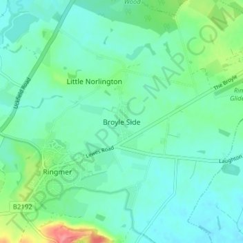
Name: Broyle Side topographic map, elevation, terrain.

Location: Broyle Side, Lewes, East Sussex, England, BN8 5PA, United Kingdom (50.88123 0.05455 50.92123 0.09455)

Average elevation: 62 ft

Minimum elevation: 3 ft

Maximum elevation: 259 ft

Other topographic maps

Click on a map to view its topography, its elevation and its terrain.

Ditchling

United Kingdom > England > East Sussex > Lewes

Average elevation: 276 ft

South Heighton

United Kingdom > England > East Sussex > Lewes

Average elevation: 236 ft

Westmeston

United Kingdom > England > East Sussex > Lewes

Average elevation: 262 ft

Ringmer

United Kingdom > England > East Sussex > Lewes > Little Norlington

Average elevation: 72 ft

Falmer

United Kingdom > England > East Sussex > Lewes

Average elevation: 381 ft

Chailey

United Kingdom > England > East Sussex > Lewes

Average elevation: 131 ft

Plumpton

United Kingdom > England > East Sussex > Lewes

Average elevation: 233 ft

Streat

United Kingdom > England > East Sussex > Lewes

Average elevation: 256 ft

Kingston near Lewes

United Kingdom > England > East Sussex > Lewes

Average elevation: 253 ft

Newick

United Kingdom > England > East Sussex > Lewes

Average elevation: 105 ft

Telscombe

United Kingdom > England > East Sussex > Lewes

Average elevation: 180 ft

Piddinghoe

United Kingdom > England > East Sussex > Lewes > Piddinghoe

Average elevation: 89 ft

Barcombe

United Kingdom > England > East Sussex > Lewes

Average elevation: 72 ft

Hamsey

United Kingdom > England > East Sussex > Lewes > Cooksbridge

Average elevation: 112 ft

Telscombe

United Kingdom > England > East Sussex > Lewes

Average elevation: 180 ft

Telscombe

United Kingdom > England > East Sussex > Lewes > Telscombe

Average elevation: 180 ft

Seaford

United Kingdom > England > East Sussex > Lewes

Average elevation: 92 ft

Plumpton

United Kingdom > England > East Sussex > Lewes

Average elevation: 233 ft

Telscombe

United Kingdom > England > East Sussex > Lewes > Telscombe

Average elevation: 180 ft

Falmer

United Kingdom > England > East Sussex > Lewes > Falmer

Average elevation: 381 ft

Gear up for your next adventure:

🦶Hiking Gaiters - Keep debris and water out of your boots
🔊Portable Camp Speaker - Music and alerts at camp
👖Convertible Hiking Pants - Versatile zip-off pants for changing altitudes and temperatures
Solar GPS Watches - Advanced multisport watches with built-in topographic maps
📷Action Camera - Capture your outdoor adventures in HD

As an Amazon Associate, this site earns from qualifying purchases at no extra cost to you.