Geolocate

Boston Heights topographic map

Click on the map to display elevation.

About this map

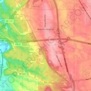
Name: Boston Heights topographic map, elevation, terrain.

Location: Boston Heights, Summit County, Ohio, United States (41.22595 -81.53314 41.28298 -81.48875)

Average elevation: 935 ft

Minimum elevation: 650 ft

Maximum elevation: 1,096 ft

Summit County trails, hiking, mountain biking, running and outdoor activities

Other topographic maps

Click on a map to view its topography, its elevation and its terrain.

Camp Crowell Dam

United States > Ohio > Summit County

Average elevation: 1,165 ft

Brandywine Falls

United States > Ohio > Summit County

Average elevation: 869 ft

Silver Springs Lake

United States > Ohio > Summit County > Stow

Average elevation: 1,093 ft

Hammond's Corners

United States > Ohio > Summit County > Bath Township

Average elevation: 1,093 ft

Greensburg

United States > Ohio > Summit County > Green

Average elevation: 1,175 ft

West Richfield

United States > Ohio > Summit County > Richfield

Average elevation: 1,178 ft

Six Corners

United States > Ohio > Summit County > Tallmadge

Average elevation: 1,148 ft

Sagamore Hills

United States > Ohio > Summit County

Average elevation: 866 ft

East Center

United States > Ohio > Summit County > Richfield > East Center

Average elevation: 1,125 ft

Gear up for your next adventure:

🛌Ultralight Sleeping Bags - Compact down bags for cold nights in the wilderness
🩹Survival Bandages - High‑quality bandages for emergencies
🥾Hiking Shoes - Durable and comfortable shoes for trail hiking
🪶Paracord Bracelet - Survival bracelet with built‑in tools
📻Weather Alert Radios - Stay informed of storm risks while off-the-grid

As an Amazon Associate, this site earns from qualifying purchases at no extra cost to you.