
Make a donation
Gear up for your next adventure:
As an Amazon Associate, this site earns from qualifying purchases at no extra cost to you.
Baia Mare topographic map
Click on the map to display elevation.
Make a donation
Gear up for your next adventure:
As an Amazon Associate, this site earns from qualifying purchases at no extra cost to you.
Baia Mare
The city is situated in the vicinity of the Gutâi and Igniș [ro] mountains. Altitudes reach 1,400 metres (4,600 feet) in some peaks. The area is famous for its outstanding landscapes, and the mountains are easily accessible from the city, notable routes being: Igniș (1,307 m), Mogoșa (1,246 m), Gutâi (1,443 m), Creasta Cocoșului (1,450 m), Piatra Șoimului (839 m), Pleștioara (803 m), Dealul Bulat (683 m), Murgau (633 m), Dealul Crucii (500 m), etc.
Make a donation
Gear up for your next adventure:
As an Amazon Associate, this site earns from qualifying purchases at no extra cost to you.
About this map
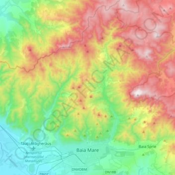
Name: Baia Mare topographic map, elevation, terrain.
Location: Baia Mare, Maramureș, Romania (47.62274 23.48205 47.85881 23.71164)
Average elevation: 1,942 ft
Minimum elevation: 476 ft
Maximum elevation: 4,285 ft
Make a donation
Gear up for your next adventure:
As an Amazon Associate, this site earns from qualifying purchases at no extra cost to you.
Other topographic maps
Click on a map to view its topography, its elevation and its terrain.