
Make a donation
Gear up for your next adventure:
As an Amazon Associate, this site earns from qualifying purchases at no extra cost to you.
Cartago Province topographic map
Click on the map to display elevation.
Make a donation
Gear up for your next adventure:
As an Amazon Associate, this site earns from qualifying purchases at no extra cost to you.
About this map
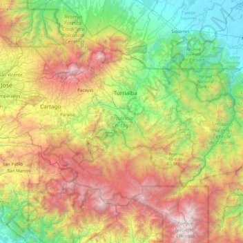
Name: Cartago Province topographic map, elevation, terrain.
Location: Cartago Province, Costa Rica (9.48431 -84.08812 10.14731 -83.31560)
Average elevation: 4,508 ft
Minimum elevation: 7 ft
Maximum elevation: 12,421 ft
Make a donation
Gear up for your next adventure:
As an Amazon Associate, this site earns from qualifying purchases at no extra cost to you.
Other topographic maps
Click on a map to view its topography, its elevation and its terrain.
Valle Azul
Costa Rica > Alajuela Province > Cantón de San Ramón > San Lorenzo
Average elevation: 741 ft
La Catarata
Costa Rica > Alajuela Province > Cantón de San Carlos > La Fortuna
Average elevation: 1,306 ft
Make a donation
Gear up for your next adventure:
As an Amazon Associate, this site earns from qualifying purchases at no extra cost to you.
Make a donation
Gear up for your next adventure:
As an Amazon Associate, this site earns from qualifying purchases at no extra cost to you.