
Make a donation
Gear up for your next adventure:
As an Amazon Associate, this site earns from qualifying purchases at no extra cost to you.
Hellefeld topographic map
Click on the map to display elevation.
Make a donation
Gear up for your next adventure:
As an Amazon Associate, this site earns from qualifying purchases at no extra cost to you.
Hellefeld
In den ältesten Aufzeichnungen wird das Dorf unter verschiedenen Schreibarten erwähnt, wie zum Beispiel hyleuelden, heliuelde und heluelde. Da diesen Begriffen die Silben hele (Höhe) und feld (Feld) zugeordnet werden können, dürfte der Name Hellefeld als „Feld an der Höhe“ zu deuten sein. Es befand sich am Abhang der hele (Höhe) ein ebener Bereich, der für Siedlungszwecke geeignet erschien.
Make a donation
Gear up for your next adventure:
As an Amazon Associate, this site earns from qualifying purchases at no extra cost to you.
About this map
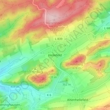
Name: Hellefeld topographic map, elevation, terrain.
Average elevation: 1,257 ft
Minimum elevation: 938 ft
Maximum elevation: 1,673 ft
Make a donation
Gear up for your next adventure:
As an Amazon Associate, this site earns from qualifying purchases at no extra cost to you.