Geolocate

Mulberry topographic map

Click on the map to display elevation.

About this map

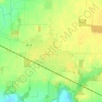
Name: Mulberry topographic map, elevation, terrain.

Location: Mulberry, Clinton County, Indiana, United States (40.33831 -86.67682 40.35234 -86.65611)

Average elevation: 778 ft

Minimum elevation: 722 ft

Maximum elevation: 807 ft

Clinton County trails, hiking, mountain biking, running and outdoor activities

Other topographic maps

Click on a map to view its topography, its elevation and its terrain.

Colfax

United States > Indiana > Clinton County

Average elevation: 843 ft

Gear up for your next adventure:

🪵Folding Camp Saw - Compact saw for wood and campsite work
🧥Waterproof Jacket for Hiking - Breathable and rugged rain jacket for outdoor excursions
🚗GPS Dash Cams - Record your scenic drives through mountain passes and canyons
Camping Coffee Makers - Enjoy premium coffee at the summit or campsite
🦶Carbon Trekking Poles - Reduce knee impact on steep descents with ultra-light poles

As an Amazon Associate, this site earns from qualifying purchases at no extra cost to you.