Colona topographic map
Interactive map
Click on the map to display elevation.
About this map
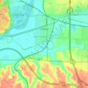
Name: Colona topographic map, elevation, terrain.
Location: Colona, Henry County, Illinois, United States (41.44097 -90.39295 41.49103 -90.31946)
Average elevation: 620 ft
Minimum elevation: 558 ft
Maximum elevation: 719 ft
Other topographic maps
Click on a map to view its topography, its elevation and its terrain.
Woodhull
United States > Illinois > Henry County
Woodhull, Henry County, Illinois, United States
Average elevation: 814 ft
Orion
United States > Illinois > Henry County
Orion, Henry County, Illinois, 61273, United States
Average elevation: 778 ft
Kewanee
United States > Illinois > Henry County
Kewanee, Henry County, Illinois, 61443, United States
Average elevation: 823 ft