Geolocate

Philip topographic map

Click on the map to display elevation.

About this map

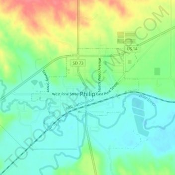
Name: Philip topographic map, elevation, terrain.

Location: Philip, Haakon County, South Dakota, United States (44.03433 -101.67721 44.04650 -101.65414)

Average elevation: 2,211 ft

Minimum elevation: 2,136 ft

Maximum elevation: 2,343 ft

Haakon County trails, hiking, mountain biking, running and outdoor activities

Gear up for your next adventure:

🪶Trail Camera - Capture wildlife on your hikes
📡GPS Antenna Upgrade - Enhance GPS reception in remote terrain
🧺Microfiber Travel Towels - Compact and fast-drying towels for trail use
🚗GPS Dash Cams - Record your scenic drives through mountain passes and canyons
📦Gear Storage Bags - Organize and protect outdoor equipment

As an Amazon Associate, this site earns from qualifying purchases at no extra cost to you.