
Make a donation
Gear up for your next adventure:
As an Amazon Associate, this site earns from qualifying purchases at no extra cost to you.
Maranguape I topographic map
Click on the map to display elevation.
Make a donation
Gear up for your next adventure:
As an Amazon Associate, this site earns from qualifying purchases at no extra cost to you.
About this map
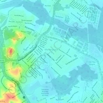
Name: Maranguape I topographic map, elevation, terrain.
Average elevation: 36 ft
Minimum elevation: 0 ft
Maximum elevation: 184 ft
Make a donation
Gear up for your next adventure:
As an Amazon Associate, this site earns from qualifying purchases at no extra cost to you.
Other topographic maps
Click on a map to view its topography, its elevation and its terrain.
Maria Farinha
Brasil > Pernambuco > Região Metropolitana do Recife > Paulista
Average elevation: 30 ft
Pracinha de jardim paulista alto
Brasil > Pernambuco > Região Metropolitana do Recife > Paulista
Average elevation: 141 ft
Make a donation
Gear up for your next adventure:
As an Amazon Associate, this site earns from qualifying purchases at no extra cost to you.
Maranguape II
Brasil > Pernambuco > Região Metropolitana do Recife > Paulista
Average elevation: 46 ft
Jardim Paulista
Brasil > Pernambuco > Região Metropolitana do Recife > Paulista
Average elevation: 121 ft
Make a donation
Gear up for your next adventure:
As an Amazon Associate, this site earns from qualifying purchases at no extra cost to you.